Islander East - Route through Branford
- The
Islander East pipeline route was carefully selected to minimize impact
on the environment and private property. The Federal Energy Regulatory
Commission states that " As approved, aproximately 83% of the proposed
pipeline either overlaps or is adjacent to existing pipeline,
powerline, railroad and road rights of way.".
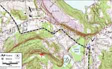
- Topo
map one, northern section pictured above, shows the Islander East
pipeline route as it enters North Branford along side an existing
Algonquin pipeline. At the top of this map is Lake Gaillard and the
Tilcon/Tomasso quarry in North Branford. The red and white dashed line
below the lake is Route 80. The dashed black and white line represents
the Islander East pipeline route.
- Mileposts
4, 5 and 6 follow the path of an existing Algonquin pipeline right of
way. Just past milepost 6 is a blue arrow where the pipeline intersects
with the Branford Steam Railroad tracks. From this point on, the
pipeline follows the tracks to Long Island Sound.
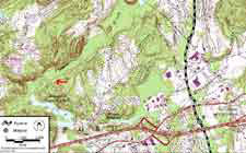
- Rights
of Way are often used for hiking trails. The red arrow towards the
bottom of this map points to a dashed line that is a telephone and
power line right of way that traverses densely forested trap rock
ridges and offers many beautiful views to hikers or cyclists.
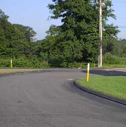
- The
Islander East pipeline, like the Algonquin pipeline pictured below,
will be safely buried underground. Waist high, yellow and white posts
will mark the path of the pipeline and serve as a warning to prevent
accidental digging.
- Small
shrubs, berry bushes and wild flowers will be allowed to bloom over the
pipeline path and attract many song birds. Tall trees which have deep
roots that could damage the pipeline will be discouraged and routinely
trimmed.
|